Griffin Greenway - Mixed Use Pathway
Last Updated: Thursday, 12 October 2023 5:33:41
 The Griffin Greenway is the working title we've been using for a city-wide mixed use path plan that focuses on providing everyone in Griffin with access to shopping, affordable commuting, outdoor fitness, and recreation.
Unlike previous plans over the years, the Griffin Greenway focuses on connecting neighborhoods to shopping and services using existing City of Griffin right-of-way. This minimizes the need for expensive property aquisition or public domain concerns. The Griffin Greenway also focuses on reconnecting areas that are currently cut off by existing transporation infrastructure such as the railroad line that bisects the town down Experiment Street and HWY 19/41 that is dangerous and difficult to cross to gain access to affordable shopping options such as WalMart, etc.
RETURN ON INVESTMENT
- Across the southeast, every $1.00 of trail construction supports $1.60-1.72 annually from local business revenue, sales tax revenue, and benefits related to health and transportation.
INCREASED JOBS AND REVENUE IN LOCAL BUSINESSES
- With the number of recreational bikers, hikers and tourists, areas with trail systems help create local jobs and increase revenue and traffic in local businesses.
- Retail and snack shops, as well as restaurants, benefit from proximity to trails and greenways and encourage new businesses to move in.
ENVIRONMENTAL BENEFITS
- By providing a safe means of travel for bikers and pedestrians, a multi-use trail design provides an alternative to vehicular travel that is emission and nearly cost-free.
HEALTH OUTCOME BENEFITS
- Those who exercise file 14% fewer health care claims and spend 30% fewer days in the hospital than those who are sedentary.
- A multi-use trail design, then, can provide a free means of healthy exercise for those in urban and rural areas alike.
REVITALIZATION OF DEPRESSED AREAS
- Trails and greenways have long been used to aid in the revitalization of depressed areas, particularly in downtown areas.
- Occupancy rates and demand universally increase in areas with new green spaces and trails.
AFFORDABLE COMMUTING AND CONNECTIVITY
- The annual cost of ownership for an average sedan with insurance, maintenance, fuel, financing: $8,500-11,000/year ($700-915 mo)
- The annual cost of ownership to a full-time bike commuter: $350/year ($29 mo)
PROPERTY VALUES
- Proximity to multi-use trails is a top requested amenity for homebuyers, according to the National Association of Realtors.
- Plots of land adjacent to trails and greenways can offer homeowners a significant increase in property value.
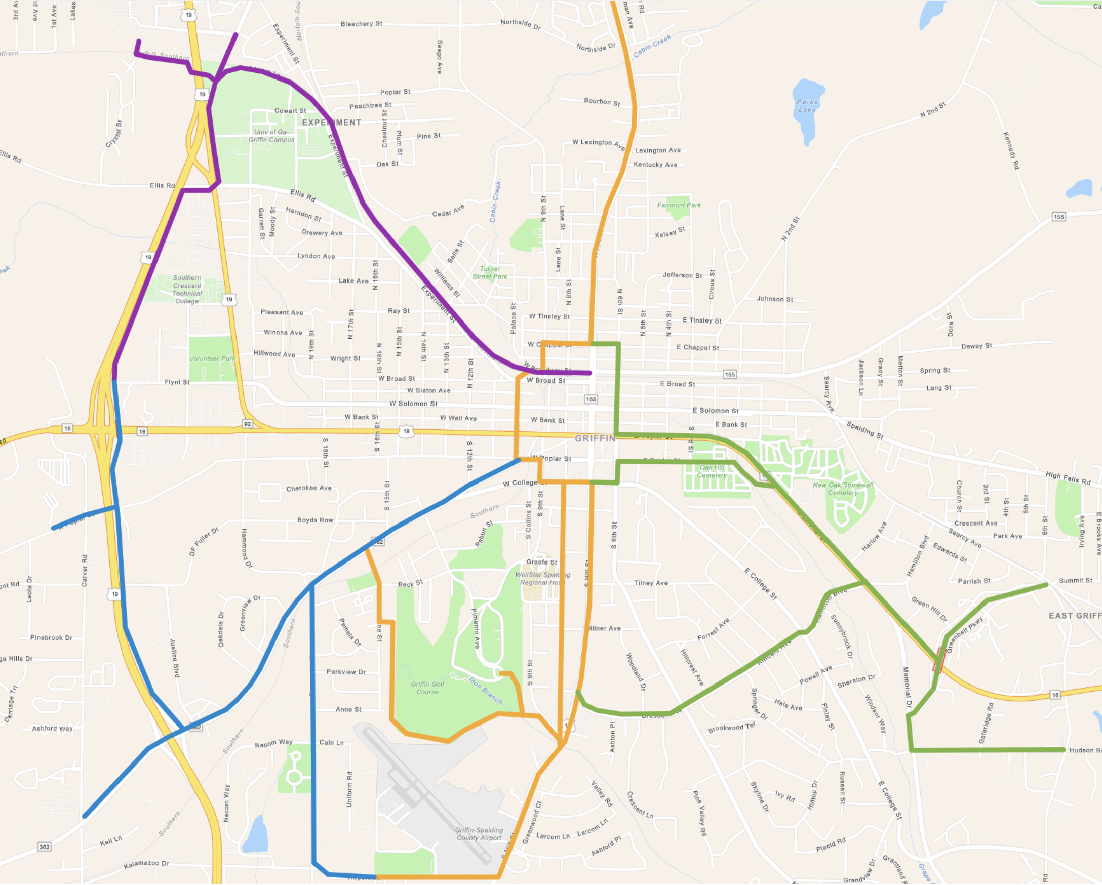
A Proposed Route Map
Linking both community and state colleges, major shopping areas, and collector roads through neighborhoods where existing travel by foot or bike is hazardous or impossible. By using a hub-and-spoke layout and existing city right-of-way along major routes this minimizes the cost of the plan while providing maximum connectivity and the ability for Spalding County to continue on at the city limits to connect areas such as Sun City, Orchard Hill, Williamson, etc.
Please note: this is an inital proposed route map. While every effort was made to select routes that are free of obstructions, utility issues, etc. some adjustment may be necessary when the route is finally engineered and built. External factors like community feedback, funding, grant limitations, and more can affect this initial concept moving forward.